Living with change: An archaeological study of human settlement patterns as environmental adaptations in Late Holocene Madagascar
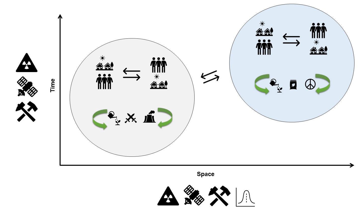
This diagram illustrates the framework developed in this dissertation to understand settlement and mobility patterns. The gray and blue circles illustrate two different communities, each of which have their own set of social and ecological feedbacks. These communities also interact with each other as part of a larger connected system, which spans both time and space. To understand these relationships, we need to consult multiple lines of evidence, indicated by symbols along the axes (e.g., chemistry, remote sensing, archaeology, etc.).
People on Madagascar have coped with environmental change for millennia. Present-day environmental change, however, is negatively impacting the livelihoods and sustainability of coastal communities on Madagascar. As a result of increasing climate-driven impacts on livelihoods and economic development initiatives, community settlement strategies are shifting towards increased sedentism. This dissertation investigates settlement patterns of mobile foraging populations, their drivers, and ecological effects in Late Holocene Madagascar. Specifically, I investigate environmental links to settlement patterns via a remotely sensed environmental and archaeological data and radiocarbon chronology from identified archaeological deposits. While most studies of settlement distribution focus on socioecological drivers, in this project I also devote attention to the ecological legacy effects of human settlement by looking at the geochemical and spectral properties of archaeologically inhabited areas. In this way, this dissertation seeks a holistic understanding of settlement distribution in Southwest Madagascar extending from its driving forces to its long-lasting effects on ecological systems. Using a predictive modeling protocol rooted in ideal distribution models from human behavioral ecology, I use machine learning algorithms to extract culturally significant environmental variables from Sentinel-2 satellite images to explore the degree to which resource distribution is correlated with settlement density in Late Holocene SW Madagascar and whether Allee effects account for settlement patterns, and the resulting ecological impact of foraging activity on the Malagasy landscape over thousands of years. Identified cultural deposits are visited during ground investigations to survey and excavate different areas to acquire temporal information (e.g., 14C dates, ceramics, etc.). Based on this newly generated archaeological settlement record, these data are incorporated into spatial point process models (PPMs), a form of regression analysis, of archaeological settlements to investigate the relationship between environmental conditions and settlement distributions. PPMs help to reveal external ecological relationships as well as dispersive or cohesive properties between archaeological points. Finally, using an automated remote sensing procedure employing a combination of Sentinel-2 and PlanetScope imagery and random forest models, I quantify the extent of cultural niche construction resulting from foraging communities in the Velondriake Marine Protected Area in southwest Madagascar since the Late Holocene. Altogether, this dissertation demonstrates that foraging communities in Late Holocene Madagascar settled the landscape according to the principles of an ideal free distribution with Allee effects, meaning that a strong mix between environmental and social factors, including active landscape modification (or niche construction) drove settlement choice. Specifically, the presence of freshwater sources, community defense, and social cohesion were among the most significant drivers of settlement patterns, followed by marine resource access (i.e., coral reefs). Additionally, it appears that almost 20% of the Velondriake region has been anthropogenically modified, demonstrating that foraging communities leave quantifiable and long-lasting impacts on ecological systems. Over the last millennium, communities in the Velondriake region have maintained close social connections, which have shifted geographically over the last several hundred years. Settlements appear to reflect a variety of long-term and seasonal occupations that exploited a variety of marine habitats including coastal coral reefs, oceans, and mangrove forests.
Related Publications
Davis, D. S., and K. Douglass (2021). Remote Sensing Reveals Lasting Legacies of Land-Use by Small-Scale Communities in the southwestern Indian Ocean. Frontiers in Ecology and Evolution. 9, 689399. https://doi.org/10.3389/fevo.2021.689399
Davis, D. S. (2020). Studying human responses to environmental change: Trends and trajectories of archaeological research. Environmental Archaeology, 25(4), 367-380. https://doi.org/10.1080/14614103.2019.1639338
Davis, D. S., Andriankaja, V., Carnat, T. L., Chrisostome, Z. M., Colombe, C., Fenomanana, F., Hubertine, L., Justome, R., Lahiniriko, F., Léonce, H., Manahira, G., Pierre, B. V., Roi, R., Soafiavy, P., Victorian, F., Voahirana, V., Manjakahery, B., & Douglass, K. (2020). Satellite-based remote sensing rapidly reveals extensive record of Holocene coastal settlement on Madagascar. Journal of Archaeological Science, 115, 105097. https://doi.org/10.1016/j.jas.2020.105097
Davis, D. S., & Douglass, K. (2020). Aerial and Spaceborne Remote Sensing in African Archaeology: A Review of Current Research and Potential Future Avenues. African Archaeological Review, 37(1), 9–24. https://doi.org/10.1007/s10437-020-09373-y
Davis, D. S., DiNapoli, R. J., & Douglass, K. (2020). Integrating Point Process Models, Evolutionary Ecology and Traditional Knowledge Improves Landscape Archaeology—A Case from Southwest Madagascar. Geosciences, 10(8), 267. https://doi.org/10.3390/geosciences10080287
